Travel Guide: Anchorage to Nabesna in the Summer

Unforgettable adventure awaits!
Truly the Road Less Traveled
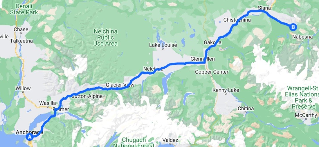
Not many folks know about the beautiful and little-traveled route from Anchorage to northern Wrangell-St. Elias National Park & Preserve, that offers numerous spectacular adventure opportunities, diverse cultures, and wide open spaces to just relax and soak in Alaska’s spirit. Having made the journey hundreds of times in nearly 60 combined years, in all of the seasons, we know just where to look for some of the most unforgettable places and the best times to visit them. If you’re looking for a unique and authentic experience that only a small handful of visitors know about, check out this route. You just might find the real, friendly, unscripted Alaska as you make your way around the dancing mountains and into the headwaters country of the legendary Copper River.
Sweeping views and glaciers along the 5-6 hour drive
Day 1
From Anchorage, head east toward Wrangell-St. Elias, with points of interest along the way:
Brief intro/overview of Glenn Hwy history you can go to https://www.alaska.org/guide/glenn-highway-guide

Do you know what makes glaciers appear blue?
Matanuska Glacier viewing wayside (outhouse) or privately owned site for glacier hike.
Check crags above Caribou Creek large paved viewing area (no toilet/outhouse, south side of highway) for Dall sheep (great with binoculars), near mile 106-107.

Dall Sheep
Continue east toward Glennallen, enjoying expansive views of an ancient glacial lake basin.

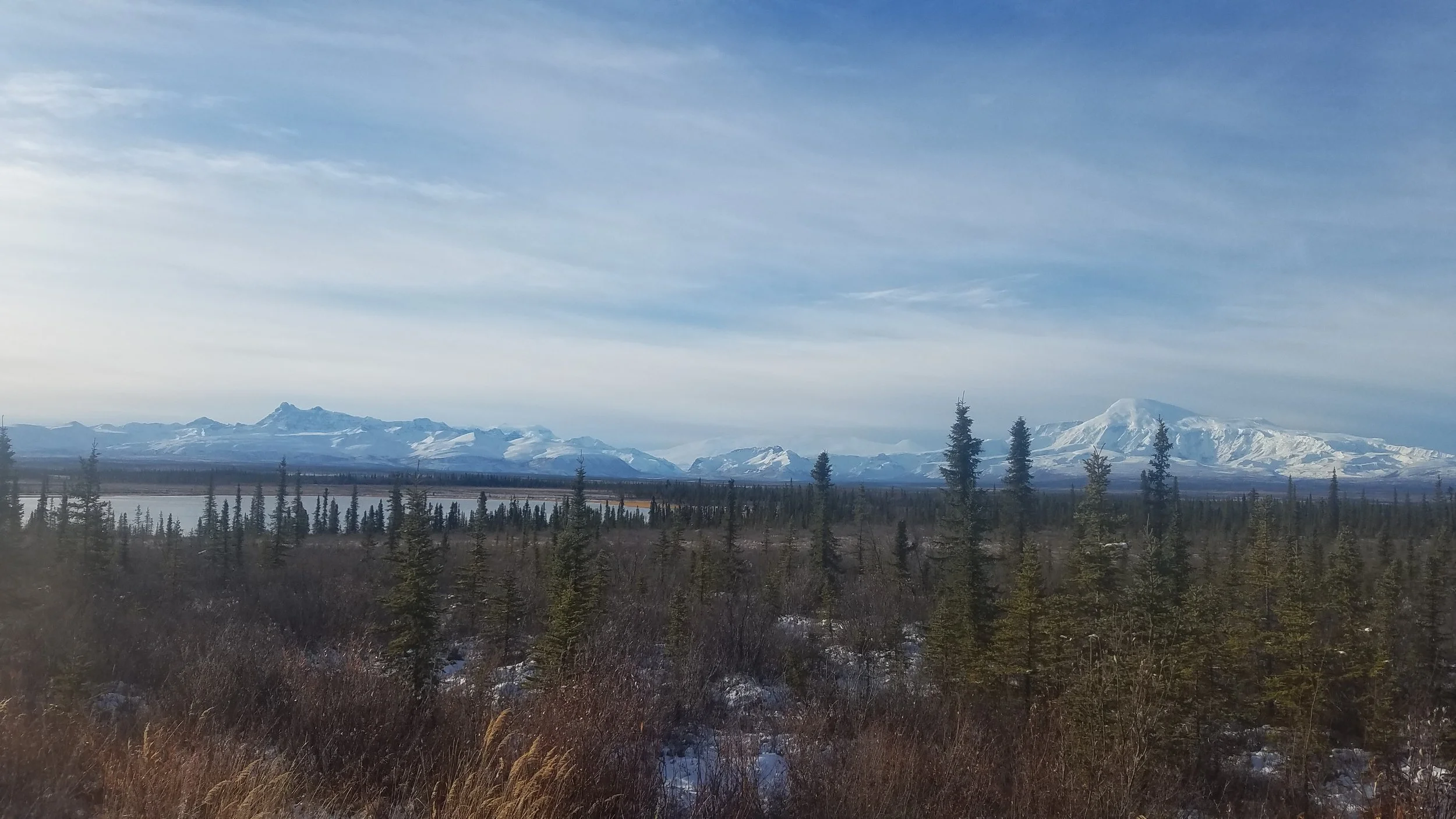
Wrangell Mountains over the Copper River
Moving east along the Glenn Hwy you'll see the impressive peaks of the Wrangell Mountains, left to right Mt Sanford 16,237 ft; Mt Drum 12,010 ft; and Mt Wrangell 14,163 ft. The local/native nickname is the "Dancing Mountains" because they appear to dance around or trade places as you view them from different places in the basin through your travels.

Nelchina Glacier, Chugach Mountains by Takeshi Sugimoto
South of the road you'll spot the sinuous Nelchina Glacier (across from Eureka) and the long Heavenly Ridge off the toe of the glacier. The next glacier visible to the east is Tazlina Glacier. This area was once part of a route miners used to traverse glaciers to Valdez; some folks still make the trek on snowmachines (what Alaskans call snowmobiles).
Outhouse rest area near Mendeltna Creek around mile 160 if needed (not on the Bell's map)
Fuel up options: Glennallen Fuel @ mile 187 Glenn Hwy before the junction (south side of hwy, old-timey gas station/garage, pay at the pump 7 days/wk, plumbed restrooms); Chistochina @ mile 33 Tok Cutoff (summer hours 7am-9pm Mon-Sat) which is much more quaint Alaska. See note below on lunch stop. The view of the Wrangell Mountains towering over the Chistochina River just beyond Posty’s at the bridge is one of the most spectacular anywhere in Alaska.
Various outhouses along the way (see Bell's travel map linked above).
--Possible Lunch stop: 4 hours drive from Anchorage puts you around Chistochina where you'll find one of the most spectacular views of the Wrangell Mountains and Chistochina River near its confluence with the Copper River - the best photo spot is from the bridge. Just before the bridge is a turnoff to a parking area with an outhouse. Posty's Trading Post in Chistochina is quaint, with gas, propane, plumbed restrooms, small general store, and nice selection of locally made Alaska Native hand crafts and art https://www.facebook.com/PostysNativeGiftShop/ with picnic tables on grass in summer.
The interpretive sign and pullout near mile 56 offers exceptional photo opportunities of the Wrangell Mountains and headwaters country of the Copper River; incredible views of the Tanada Peaks and Capital Mountain.
The volcanoes of the Wrangell Mountains
Mount Sanford is the tallest of the western Wrangell volcanoes at 16,237 feet (4,949 m), the 13th highest peak in North America. It is a complex shield volcano that first formed about 900,000 years ago. The latest eruption is estimated to have been between 320,000 and 100,000 years ago. Like Drum, Sanford has a large icefield above 8,000 feet (2,400 m) that feeds a series of glaciers.[43] Capital Mountain is located near Mount Sanford, but is much smaller at 7,731 feet (2,356 m) in height. It is a shield volcano, about 10 miles (16 km) in diameter. Its summit has collapsed to form a caldera roughly 2.5 miles (4.0 km) in diameter.
Tanada Peaks on left and Sanford on the right
Did you know that Wrangell St. Elias NP is the same size as Yellowstone National Park, Yosemite National Park, AND Switzerland combined?!

Skookum Volcano
The Skookum Creek Volcano is a volcanic center that has been heavily eroded. It was active between 3.2 million and 2 million years ago. 7,125 feet (2,172 m) high at its highest point, the old shield volcano has been severely eroded. Its caldera is surrounded by a series of dacite and rhyolite domes. Mount Jarvis is a shield volcano. 13,421 feet (4,091 m) high, with one or more indistinct summit calderas. It is covered with ice and erupted between 1.7 million and 1 million years ago.[46] Mount Blackburn is at 16,390 feet (5,000 m) the highest point in the Wrangells, the 12th highest peak in North America, and the oldest volcano in the range. It is a shield volcano with a filled caldera that was active between 4.2 million and 3.4 million years ago. Mount Blackburn is ice-covered and is the source of Kennicott Glacier and Nabesna Glacier, among others.[46] The Boomerang volcano is a very small shield volcano, only rising 3,949 feet (1,204 m). It is at least one million years old and is overlaid by deposits from Capital Mountain.*
Stop at NPS Ranger Station in Slana or turn on the Nabesna Road audio tour downloaded from: https://www.nps.gov/wrst/learn/photosmultimedia/audio-tours.htm The ranger station is small, with a few interpretive items, friendly rangers, and an outhouse nearby.
Enjoy a leisurely drive of the Nabesna Road (more details https://www.nps.gov/wrst/planyourvisit/nabesna-road-guide.htm ) with stops at waysides near miles 16 and 17 for a great view of a lake very reminiscent of Wonder Lake and Denali, with Tanada Peaks and Mount Sanford instead; the wayside at mile 18 to view the geology of the Mentasta Mountains (picnic tables & outhouse).

Trail Creek (approximately 1 mile from the lodge)
Take a quick (or more leisurely depending on time table) "hike" (walk) and wildlife viewing at Twin Lake / Kendesnii campground. Kendesnii is the Ahtna name for Daisy Nicolai, an Athabaskan woman who had a spring camp with her children in the area for many years near the turn of the 19th-20th century. More ethnographic information can be found here on various points along the Nabesna Road in terms of human cultures in the area.

Raven Cabin nestled in the trees