Hiking the Nabesna Road : Where to Go Summer Edition
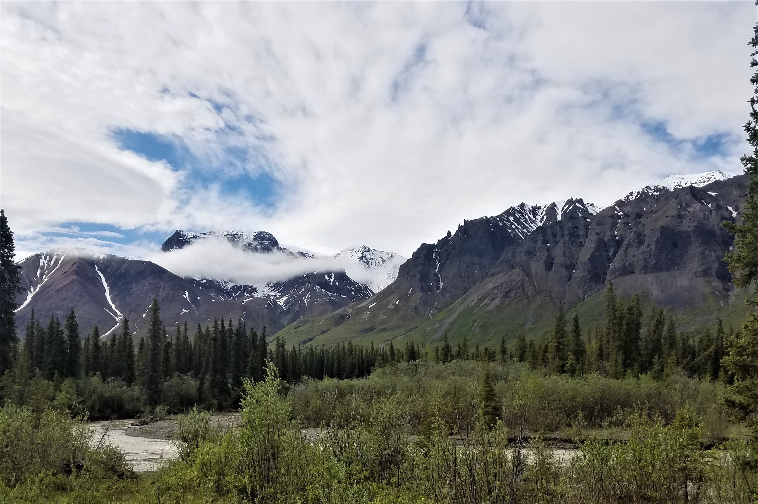
Cloud-draped crags, pinnacles & peaks rise above Jack Creek
A common question visitors ask is, “What should we do while we’re visiting?”
Here in northern Wrangell-St. Elias National Park & Preserve, you won’t find the built-up developments, main street crowds, or noisy traffic like the south side of the park at McCarthy or in Denali National Park. What you will find is like nowhere else: millions of pristine wilderness acres, jaw-dropping mountain views, wildlife up close, and the opportunity to experience the Last Frontier much as the first explorers did—with only a spruce grouse or caribou as the other traffic on your route.
If a fly-out or boat-in-only trip doesn’t fit your schedule or budget (unpredictable weather delays & cancellations are common to Alaska’s expensive backcountry access); or if you’re looking for world-class vistas, true Alaskan wilderness adventure, or the feeling of having the park all to yourself—any time of year— this is the place for you!
The Journey here
Having made the trip many times over the years, we have come to appreciate the spectacular scenery all along the 5 1/2-hour drive from either Fairbanks or Anchorage (where the state’s international airports are). From coastal mountains and cliffside Dall sheep to vast sweeping glacial basins and endless taiga, the journey to our place is a memorable activity in itself. There are numerous waysides and postcard-worthy photo locations easily accessed from the highway that offer pleasant picnic or hiking options. As you get nearer, you’ll leave the state highway (AK-1 Tok Cutoff) and turn on to the historic Nabesna Road that traverses multiple ecosystems and habitats, all ringed by incredible mountains. In fact, the “Dancing Mountains” is a local nickname for the Wrangell peaks, which seem to change places as you view them from different parts of the Copper River basin.

Endless skies, warm summer sun, & wilderness calm:
The Nabesna Road invites your imagination to adventure.
You can download the National Park Service’s audio tour guide for the Nabesna Road here: https://www.nps.gov/wrst/learn/photosmultimedia/audio-tours.htm This provides a nice introduction and some history of the area as you make way mile-by-mile down the road to our place. We have additional resources on-site if you’re interested in learning more about the area’s natural and cultural histories. With a little pre-planning and insider info, you can spend an enjoyable day or half-day seeing much of the best Alaska offers find yourself at the end in the biggest national park in North America!
Skookum Volcano

Skookum Volcano viewed along Nabesna Road (Photo: V. Rego)
One of the most popular hikes in this part of the park, yet still only seen by a handful of people each year, the Skookum Volcano trail takes you through a spruce forest and up a rocky creek into treeless alpine reminiscent of Utah’s desert country. The higher you go, the better the views get! Dall sheep can be seen perched on the pinnacles and cliff faces nearby, as well as moose, bears, and numerous raptors. This is Alaska and wilderness safety precautions should be taken for the most enjoyable trip. The trail peters out a couple miles in, but hikers can continue on exploring and taking in the amazing scenery.
From the National Park Service:
“Skookum Volcano Trail at Mile 36.2 Nabesna Road is 2.5 miles one-way to a beautiful high pass. The trail leads through an extinct, deeply eroded volcanic system with fascinating geology. The elevation at the trailhead is 3,000' and rises to an elevation of 4,800' at the pass. Hikers can explore other routes or expand this hike into a multiple-day trip. At this area along Nabesna Road, the jagged peaks south of the road are dominated by volcanic rocks ejected from the Skookum Creek Volcano. Volcanic Ash and hot gasses formed a fiery cloud which flowed down the flanks of the volcano to produce the tan and light gray rocks. Lava which issued from several volcanic vents flowed downslope and solidified to produce the more massive pinkish-tan and rust colored rocks. Radioactive dating of these rocks by USGS investigators shows that Skookum Creek Volcano was active between two and four million years ago. Deep canyons and steep slopes show that erosion has been very effective in wearing down the land during the last two million years.
Latitude: 62.51268869904652 Longitude: -143.23236345229557”
Accessed at: https://www.nps.gov/places/skookum-volcano.htm
A really nice article with great photos of the volcano by Michael Engelhard is here: https://alaskamagazine.com/authentic-alaska/activities/hiking-skookum-an-alaska-volcano/
A hiker’s video of what the trail conditions are like: https://www.youtube.com/watch?v=V8R2zVgdL3M

View from Skookum Volcano trail (Photo: NPS, https://www.nps.gov/places/skookum-volcano.htm, accessed 11/27/2022)

The striking colors of Skookum Volcano are well-worth the hike
Rambler Mine Trail
Another excellent hike is the short and somewhat steep Rambler Mine Trail which rewards hikers with sweeping views of the Nabesna River valley and Nutzotin Mountains. You’ll also find an abandoned gold mine entrance and historic remains that climb even higher up the mountain. The trail is about a mile long, up moderately steep yet solid switchbacks through a pleasant mixed spruce-alder-birch canopy, which can be refreshingly shady on a hot summer’s day or sparkling magical on a frosty autumn morning. You may see spruce grouse or snowshoe hares along the well-treed way. This is a great quick hike to add on after either Skookum Volcano, or just to stretch your legs after a leisurely drive of the Nabesna Road.
The road isn’t maintained beyond here—PLEASE HEED THE WARNINGS and don’t attempt to drive any further as the road has disintegrated substantially. There is no local towing or cell phone service, and the residents who live here are elderly and should not be relied on for assistance.
For trailhead access and more information, visit the National Park Service description sheet here:
https://www.nps.gov/wrst/planyourvisit/upload/Rambler-Mine-Trail.pdf

An excited explorer at the trailhead
The perfect quick hike for gaining some elevation and views of the Nabesna River Valley.

The Nabesna River valley and Nutzotin Mountains with historic tram cable visible upper left (Photo: V. Rego)
Caribou Creek Trail

Excellent views, abundant boreal flora and fauna, easy hiking, and roadside access make this an excellent half-day adventure. Beginning around mile 19 of the Nabesna Road, the recently restored Caribou Creek trail gradually climbs 3 miles into the Mentasta Mountains to give hikers unparalleled views of the Wrangells. From late May through August, you’ll see numerous wildflowers—bluebells, tundra rose, fireweed, mountain avens, monkshood, cottongrass, and more. A sharp eye will find moose, wolf, coyote, fox, grouse, and maybe even bear sign as you make your way along this trail. Once you reach the public use cabin at the end of the maintained trail, you will find multiple game trails and routes leading higher into the mountains for even more spectacular views.
More info from recent hikers can be found here: https://www.alltrails.com/trail/us/alaska/caribou-creek-trail

Autumn colors are spectacular in the mountains here from mid-late August through September

Ptarmigan change from brown summer plumage to white in winter for camouflage from predators and can be spotted year-round here
other Activities :

Canoeing on Twin Lake is a great way to soak in the beauty and tranquility of
Wrangell-St. Elias National Park & Preserve
Trumpeter swans, golden eagles, & Arctic terns are often sighted around the lake.

The Arctic grayling is a unique &
colorful catch from the area’s waters
They can often be seen rising to sip snacks from the surface of both Twin and Jack lakes.
Take a leisurely walk around Twin Lake, about 7 minutes away, and look for belted kingfishers, nesting trumpeter swans, swimming beaver and muskrat, or moose in the willows. The park service has tucked a few reflecting benches in the trees along the campground trail around the lake for you to enjoy the sights, smells, and sounds of Alaska’s wilderness.
Walk out to Jack Lake, about 15 minutes away, and fish for arctic grayling or lake trout, or take advantage of excellent wildlife and landscape photography on the lake’s shore.
Rent our pedal boat or canoe and cruise around the lakes for spectacular mountain views, accompanied by the many different waterfowl and wildlife who visit each season.
Take an easy bike ride up to Trail Creek (1 mile away) or Lost Creek (3 miles away) and hunt for unique rocks from multiple volcanic events or spot eagles soaring overhead.
Make the scenic drive to the end of the road, stopping at the Jack Creek Wayside (7 miles away) and look for Dall sheep on the green Boyden Hills (bring binoculars/borrow some from the lodge). Kick off your shoes and relax with a creek side picnic. The fishing can be good here as well. Look for caribou, moose, wolves, and bears in the meadows along the way.
Borrow a film or bocce game from the lodge to enjoy with family or friends, or shoot a round of pool or darts in the lounge.
Enjoy your own personal campfire and build s’mores with supplies from the lodge. We’re happy to assist getting your fire going when conditions allow!

Twin Lake offers excellent wildlife viewing & nature photography opportunities

Enjoy your own creek-side beach on a warm sunny afternoon & look for Dall sheep in the hills above
